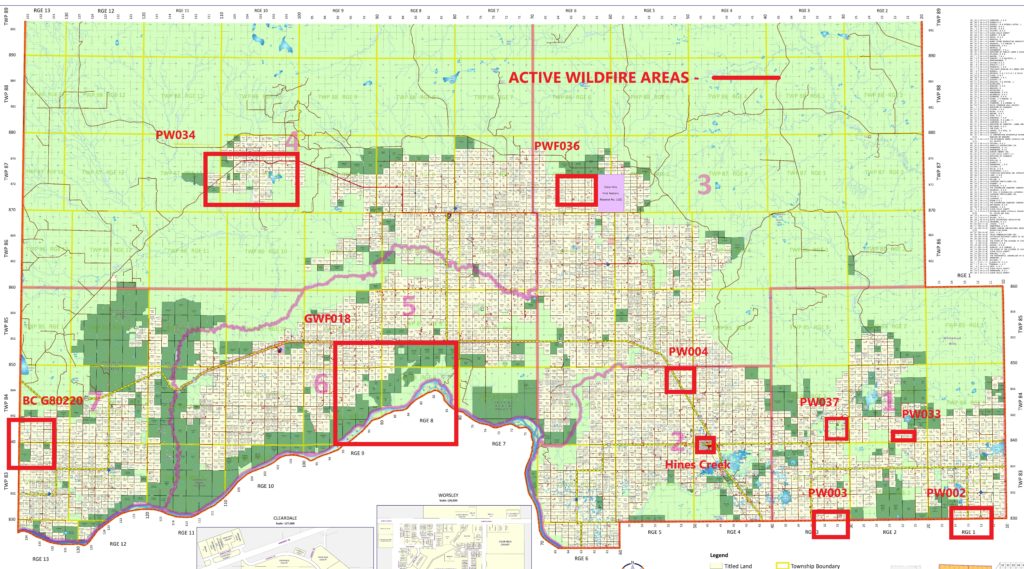
Updated wildfire map for Clear Hills County
Please refer to the map for location of the following updates:
Out of control
PW0034 – Clear Prairie
Has been 99% contained it is still considered out of Control
GWF0018 – Peace River banks/Cleardale
Considered out of Control, a fire guard is currently being cut along the east side down to the Peace River. It is currently ½ mile south of HWY 64
PW0036 – Eureka River
Currently being held – on watch
PW004 – Montagneuse Valley
Currently being held – on watch
PW0037 – Deer Hill
Currently being held – on watch
PW0033- Deer Hill
Currently being held – on watch
PW003- Gage area (NPRL)
Considered out of Control, Fire Guard around
PW002-Whitelaw
Currently being held – on watch
Please note the red outlined areas on the map are still considered out of control areas. These areas are dangerous with winds expected to increase throughout the day, you are asked to stay alert and be prepared.
If there is a threat of fire in your area:
![]() listen for updates from authorities
listen for updates from authorities
![]() be prepared to evacuate at a moment’s notice
be prepared to evacuate at a moment’s notice
![]() have your vehicle stocked with supplies and ready to go
have your vehicle stocked with supplies and ready to go
Fire crews are working diligently to keep you safe.
DO NOT attempt to fight these wildfires as they are dangerous if you see a new fire please CALL 310-FIRE (3473).
To access the Alberta Wildfire status map click on the link below